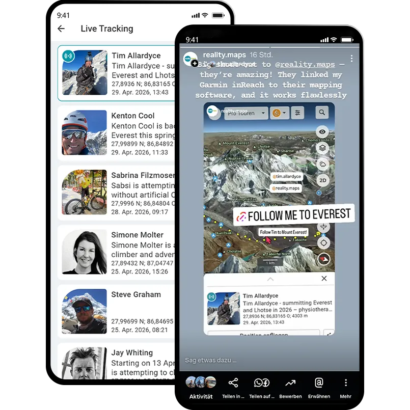
The Himalayas in photorealistic 3D
We’ve taken our popular and widely used 3D RealityMaps Outdoor app to the next level for you: high-resolution 3D data for the Himalayas is now available.
Experience the first app that shows the “Roof of the World” exactly as it really is. Our photorealistic 3D map in the highest resolution provides you with unique insights into legendary trekking routes and the challenging ascents to the world’s highest eight-thousanders. Where conventional maps reach their limits, we make every detail of the mighty mountain world visible.
We have pioneered the way and digitally mapped tours for the entire high-altitude mountain range of Nepal. In the app, you’ll find route maps and tour descriptions for more than 250 trekking tours and ascents to mountain peaks up to 6,500 m in height. We’ve also digitized the ascents to the base camps and the expedition routes to all 8,000-meter peaks in Nepal.
The Technology Behind the Card: Facts & Figures
Highly Detailed 3D Map
We use high-resolution aerial and satellite imagery to provide the most accurate representation of the terrain. You can see the nature of the terrain—whether forest, scree, or glacial ice—even while planning at home.
Topographic Map
Contour lines, slope gradients, and relief—ideal for assessing inclines and planning ascents and descents.
250+ trekking routes
Fully digitized trails including key waypoints such as lodges, water sources, and points of interest
Offline storage management
Thanks to intelligent compression technology, you can download entire regions (e.g., the Khumbu region or the Annapurna massif) in high quality
At home
Plan your tour directly on the 3D web map on a large screen, even off the beaten path, or discover new destinations
All synchronized
Saved routes are automatically stored in your RealityMaps account and are available anywhere
On the go
Open the route in the app while you’re on the go and follow your plan exactly
Route planning directly on the 3D map
With our intuitive route planner and app, you can become an explorer yourself. Create your own personalized routes directly on the photorealistic 3D map with just a few clicks. Thanks to the spatial representation, you can immediately identify terrain features, slopes, and obstacles—a crucial advantage when planning tours in off-trail terrain. This allows you to navigate safely off the beaten path and reach new, undiscovered places.
For even more inspiration, the app offers you maximum flexibility: You can easily import tours and tracks from the internet (e.g., as GPX files). Whether it’s insider tips from blogs, routes from professional portals, or recommendations from friends—simply upload them to the app and use them immediately in the 3D view.
Precise Tracking & Live Performance
Track your route with pinpoint accuracy using GPS during your tour. Keep a close eye on your personal performance at all times:
Time Management: See exactly how long you’ve been on the go and how much time you need for each stage.
Elevation Check: Track in real time how many meters of ascent and descent you’ve already covered.
Speed: Analyze your pace—from a leisurely climb to a fast trail run.
With the built-in GPS tracking feature and photorealistic RealityMaps technology, your smartphone becomes a powerful hiking companion
Share your adventures with a global community